Bloody Friday: Mapping the horror of IRA fatal bomb blitz across Belfast exactly 50 years ago today – News Letter tries to cut through the confusion around how many bombs were planted
and live on Freeview channel 276
The below timeline of the atrocity, 50 years ago today, is based mainly on the work of Ulster University academic Martin Melaugh, who runs the Conflict Archive on the Internet (CAIN) site.
At the same time there is another, quite different timeline, drawn up by the Northern Ireland Office (NIO) shortly after the aftermath of the 1972 attacks.
Advertisement
Hide AdAdvertisement
Hide AdThe News Letter used this NIO timeline to fill in some blanks in the CAIN one; specifically what time the Garmoyle Street and Salisbury Avenue bombs went off, and the details of explosions at Smithfield bus station and Creighton’s Garage (which go unmentioned in the CAIN list).
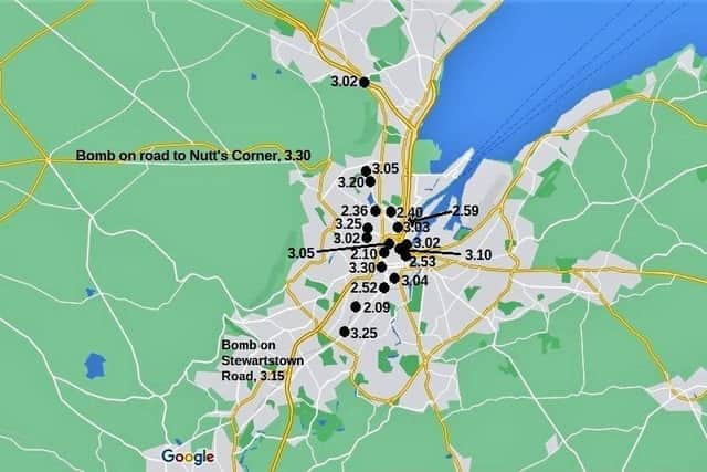

Examining the CAIN and NIO timelines side-by-side leads this reporter to estimate – conservatively – there were at least 22 explosions at 21 different locations, as follows:
l > 2.09pm: Railway line bridge, Windsor Park, south Belfast
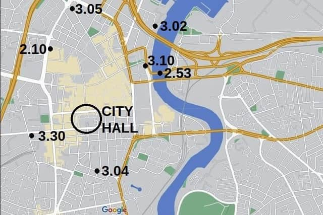
l > 2.10pm: Smithfield bus station, city centre
l > 2.36pm: Brookvale Hotel, north Belfast
l > 2.40pm: Ulster Bank, north Belfast
l > 2.52pm: Botanic Railway Station/York Hotel, south Belfast
l > 2.53pm: Queen Elizabeth Bridge, city centre
Advertisement
Hide AdAdvertisement
Hide Adl > 2.59pm: Seed business, Garmoyle Street, north Belfast
l > 3.02pm: Agnes Street, north Belfast (CAIN gives the targets as ‘a group of Protestant houses’; this bomb goes unmentioned in the NIO’s account of the day, possibly due to confusion over the fact it was near another attack on the Crumlin Road, listed below)
l > 3.02pm: Liverpool Bar / Liverpool ferry terminal, Donegall Quay, city centre
l > 3.02pm: Bellevue motorway bridge, north Belfast
l > 3.03pm: York Street train station, north Belfast
l > 3.04pm: Ormeau Avenue gasworks, south Belfast
l > 3.05pm: Eastwood’s Garage, Donegall Street, city centre (some sources give this as Donegall Road, which is in south Belfast, but a recent eyewitness account from John Linehan places it in Donegall Street)
Advertisement
Hide AdAdvertisement
Hide Adl > 3.05pm: Junction of Salisbury Avenue and Hughenden Avenue, north Belfast
l > 3.10pm: Oxford Street bus depot, city centre
l > 3.15pm: Stewartstown Road, south Belfast (exact target unclear according to CAIN; the NIO account of the day does not mention this bomb at all)
l > 3.20pm: Cavehill Road shops, north Belfast
l > 3.25pm: A bomb “exploded on the railway line near the Lisburn Road” according to the CAIN timeline.
But this is a tricky one.
The NIO’s timeline lists an explosion on a railway bridge at Finaghy Road North (which lies off the Upper Lisburn Road) and gives the time as 3.05pm.
Advertisement
Hide AdAdvertisement
Hide AdIt then mentions another bomb at Creighton’s Garage, a few hundred yards away on the Upper Lisburn Road, also at 3.05pm.
This raises the possibility that these might be one and the same incident.
An eyewitness from the day tells the News Letter that there was definitely a bomb at Creighton’s, because he was there, and that he remembers reports of a device on the Finaghy railway line too.
If there were indeed two separate explosions – one at the railway line and one at Creighton’s – that would take our original estimate of 22 blasts up to 23.
Advertisement
Hide AdAdvertisement
Hide Adl > 3.25pm: Crumlin Road, Belfast (CAIN mentions two bombs at one location and says it is the Star Garage, whilst the NIO says it is a taxi depot)
l > 3.30pm: Road on the way to Nutt’s Corner, west of Belfast (NIO does not mention this at all)
l > 3.30pm: ‘NI Carriers Depot’ on the city centre’s Grosvenor Road, according to CAIN (the NIO mentions a bombing at Great Victoria Street public transport hub, which may well be the same incident)
Advertisement
Hide AdAdvertisement
Hide Ad