This map shows which Belfast streets would be submerged if sea levels rise


Developed by Climate Central, an independent organisation of leading scientists and journalists, the interactive tool known as Surging Seas allows users to input their hometown and observe the impact a rise in temperature could have on sea levels.
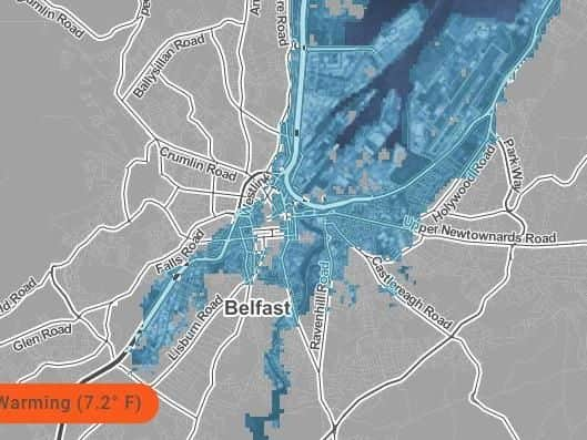
At the Paris agreement 194 states and the European Union signed an agreement which would set the long-term goal of keeping temperature rises down to 2C - despite this the rise could still see large parts of Belfast submerged by rising sea levels.
Advertisement
Hide AdAdvertisement
Hide AdAccording to Climate Central's Surging Seas map Newtonards Road, Sydenham Bypass and portions of the Shore Road could be submerged in the event of the marginal rise in temperature.
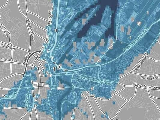
The River Lagan would in all likelihood burst its banks seeing the submersion of sections of Ormeau Road, as well as Cromac Road and Oxford Street, while the city's harbour would be completely submerged.
At current rates the world's temperature is set to rise to 3.8C by 2100, according to the Climate Action Tracker - this would cause even more devastation to Belfast, according to the Surging Seas map.
A 4C rise would see North Queen Street and York Road turned into wetlands, while Great Victoria Street and the West Link could also be engulfed by the rising sea levels.
'Rigorous research'
Advertisement
Hide AdAdvertisement
Hide AdAccording to Climate Central their map "strives to provide accurate, clear and granular information about sea level rise and coastal flood hazards both locally and globally, today and tomorrow.
"Anchored in rigorous primary research, our work distinguishes itself by its user-friendly maps and tools, extensive datasets, and high-quality visual presentation.
"The program dedicates its efforts to helping citizens, communities, businesses, organisations, and governments at every level to understand the consequences of different carbon pathways and to navigate the shifting waters of our warming world."
You can check how your hometown and address would be affected with the Surging Seas map at choices.climatecentral.org