Revamp of constituency boundaries may put unionist seats at risk


The proposals – which are open to parties and the public to comment on – would cut the number of constituencies in Northern Ireland from 18 to 17.
The new boundaries would apply during both Westminster and Assembly elections.
Advertisement
Hide AdAdvertisement
Hide AdWith moves already afoot to cut the number of MLAs per constituency from six to five, the plan – if enacted – would not just see the Province lose a single MP’s seat, but would see the number of MLAs cut from 108 at present to 85.
Although political parties have had little time to fully digest the scale of the Boundary Commission for Northern Ireland’s proposed changes, it appears from an initial glance that they could put some unionist seats at risk, and potentially bolster Sinn Fein.
Plans had been under way to redraw the map since about 2010, but initial attempts by the coalition government floundered.
It is expected new constituencies will be in place by 2020, when it is anticipated the next general election will take place.
Advertisement
Hide AdAdvertisement
Hide AdHowever, the Boundary Commission has stressed that the new-look map is only a draft, and can still be altered via public input.
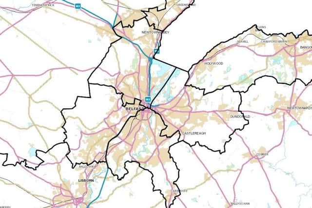
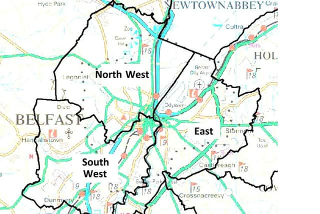
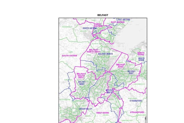
Among the major changes in the new map is the planned disappearance of the Belfast South constituency.
Where previously there was one constituency each for north, south, east and west, the idea is to shift the boundaries to create new constituencies called Belfast South West, Belfast North West, and Belfast East.
The change is likely to be bad news for the SDLP when it comes to Westminster elections, since its former leader Alasdair McDonnell has held the seat since about 2005 (one of only three SDLP MPs in the Province).
Advertisement
Hide AdAdvertisement
Hide AdMeanwhile, the old border of Belfast North would move south, taking in all of the loyalist Shankill and Woodvale wards, but also the republican-dominated wards of Falls, Clonard, and Beechmount, among others.
At the same time, its northern edge will be redrawn to exclude Rathcoole ward – a major loyalist heartland.
While Nigel Dodds of the DUP currently holds the Westminster seat of Belfast North (with 47% of the vote in 2015, against Sinn Fein veteran Gerry Kelly’s 34%), if the constituency ends up being redrawn along these lines, it could make it harder to defend as a unionist seat.
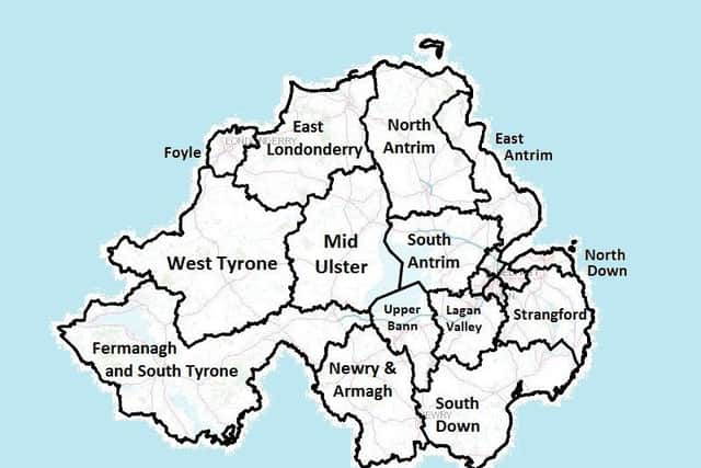
Whilst some have kept their original names, other constituencies would attain new ones if they are redrawn according to the Boundary Commission’s plan.
Advertisement
Hide AdAdvertisement
Hide AdFor instance, much of the northern part of the Province would be reimagined, doing away with Mid Ulster (represented at Westminster by Sinn Fein MP Francie Molloy), East Londonderry (Gregory Campbell MP, DUP), and North Antrim (Ian Paisley MP, DUP).
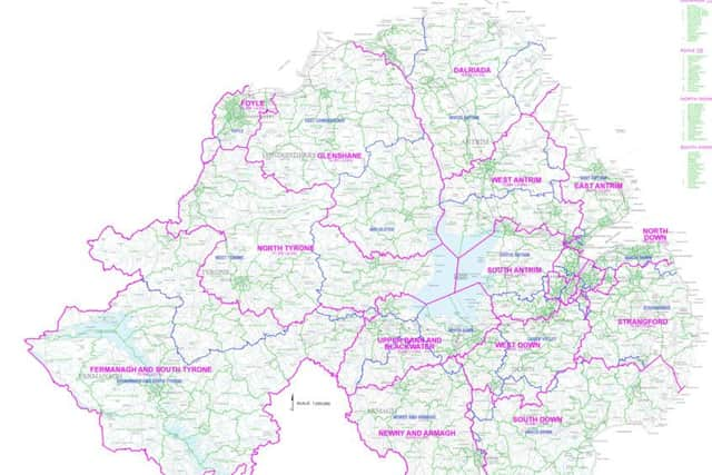
In place of much of East Londonderry and Mid Ulster would be a big new constituency called Glenshane.
Meanwhile, in North Antrim a new constituency would emerge called Dalriada, which would encompass the large Protestant-dominated town of Coleraine, and also extra bits of the north-east Antrim coast.
Ballymena, meanwhile, would become part of a new constituency called West Antrim.
Advertisement
Hide AdAdvertisement
Hide AdOn the other side of the Province, Fermanagh and South Tyrone would expand northward to take in Fintona and Castlederg, but would lose the large town of Dungannon to the new constituency of Upper Bann and Blackwater.
Fermanagh and South Tyrone has been an extremely hard seat for unionists to take control of.
In last year’s Westminister election, the DUP and UUP struck a pact to field Tom Elliott as the only pro-Union candidate, in order to ensure unionists emerged dominant.
Even then, the UUP man won by little over 500 votes.
It is thought the seat could become even harder to defend for unionists thanks to the latest changes.
Advertisement
Hide AdAdvertisement
Hide AdOne elections expert, who asked not to be named, summed the situation up as follows: “This is purely bad news for the SDLP and probably better news for Sinn Fein than for the other parties in terms of Westminster.
“In terms of Stormont, it’s difficult to say at this rate.”
While the major Northern Ireland parties were being circumspect in their official statements after the plans began circulating among press and politicians yesterday, one DUP source specifically mentioned Fermanagh and South Tyrone as an area of concern.
They told the News Letter: “There’s a bit of unease that some of the constituencies appear to be somewhat unnatural and unwieldy, and there is an initial concern as to how it will play out in terms of the number of unionist seats, I suppose particularly at Westminister.”
WHY ARE THE CHANGES HAPPENING?
The reason behind the planned changes is to try and equalise the number of voters in each constituency.
Advertisement
Hide AdAdvertisement
Hide AdPreviously, constituencies ranged in size in terms of electorates from 62,643 in Belfast West to 80,251 in Upper Bann (according to 2008 figures).
Under the latest plans, the numbers would be much more level, ranging from 71,266 in Belfast North West to 74,741 in Strangford.
When deciding the shape of the new constituency boundaries, the boundary commission considered geographical features (like loughs or rivers), “local ties” (such as the existence of established “organic communities”), and the existing shape of the borders.
They were not permitted to take the unionist/nationalist split into account.
Advertisement
Hide AdAdvertisement
Hide AdThe public consultation into the plans is now under way, and will close on November 28.
To submit representations, write to Eamonn McConville, Secretary to the Boundary Commission, The Bungalow, Stormont House, Stormont Estate, Belfast, BT4 3SH.
Alternatively, email: [email protected]
For more details, see: www.bcni2018.uk