Unionists cautious about new election map while SF fume over '˜gerrymandering'


When the previous plans emerged in 2016, unionists had voiced unease over them.
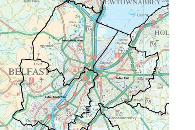
The 2016 proposals to change Belfast North (where the MP and two out of five MLAs are now unionist) into Belfast North-West may have tipped the balance in favour of republican candidates.
Advertisement
Hide AdAdvertisement
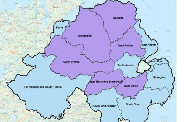
Hide AdMeanwhile, altering the boundaries of Fermanagh & South Tyrone (where two MLAs are unionist, and where the UUP and Sinn Fein vie for the MP’s seat with just a handful of votes between them) could also have cost unionism dearly.
Under those 2016 plans, the constituency would have taken in a raft of countryside in southern Tyrone.
But the accidentally released draft map shows these particularly hard-fought constituencies appear to be set for fewer changes compared with their present form – something which may prove a relief for unionists in these areas.
Nelson McCausland, former DUP MLA for North Belfast (who lost his seat in 2016), stressed that the full impact of the new blueprints was unclear, but that it was “important” to keep four seats for Belfast, instead of three.
Advertisement
Hide AdAdvertisement
Hide Ad“I think people have got a general sense of identification with the [current] constituencies in Belfast,” he said.
“Certainly if it’d moved to three seats as proposed [in 2016], it’d have given an outcome that would have been very unrepresentative of the city.”
The result in those circumstances could have been Sinn Fein MPs taking Belfast North-West and South-West, and Alliance taking East Belfast – leaving the capital with zero unionist representation in the House of Commons.
UUP grandee Lord Empey offered an extremely tentative take on the latest draft map.
Advertisement
Hide AdAdvertisement
Hide AdHe said even if it is the latest draft, “it is difficult to ascertain the fine detail which is so important”.
However, he said the new draft map does “contain a number of anomalies where long-standing communities and areas are divided or cut off from their natural and historic hinterlands”.
When the new draft plans are published he said the UUP “will study them with interest”.
Francie Molloy, Sinn Fein MP for Mid Ulster, said the new plans would ensure “constituencies reminiscent of those drawn up by the unionist one-party state decades ago”.
Advertisement
Hide AdAdvertisement
Hide AdHe added: “The Boundary Commission should immediately clarify whether the media reports of the amended proposals are accurate because, if they are, it would mean that the Tories have again acquiesced to the DUP’s anti-democratic agenda, just as they have done on issues such as equal marriage, the Irish Language and legacy inquests.
“That is entirely unacceptable and further evidence of the British government’s ongoing refusal to act in an impartial manner as they are obliged to under the terms of the Good Friday Agreement.”
Electoral expert Nicholas Whyte said that the new draft blueprints are “not too far off my own proposals”, and praised the new map as “much better” than that for the original 2016 proposals.
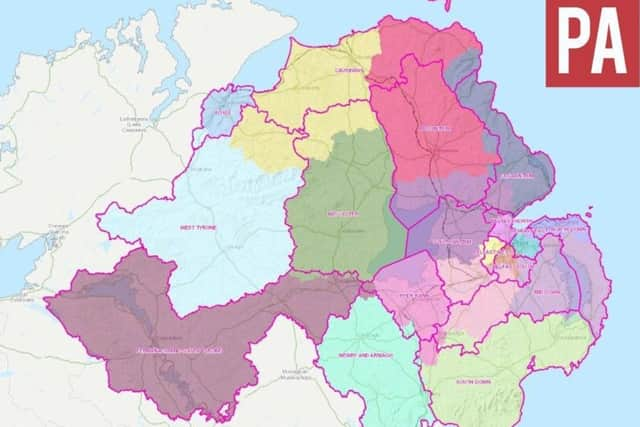
WHAT IS HAPPENING, WHY, AND WHEN?
The redrawing of the constituency boundaries is happening because the government is trying to implement a long-running plan to cut the number of MPs’ constituencies from 650 to 600, something which will see Northern Ireland drop from 18 to 17 seats.
Advertisement
Hide AdAdvertisement
Hide AdThere is also a need to balance out the number of people in each constituency to make them roughly even.
The Boundary Commission are prohibited from taking political considerations into account when re-drawing election maps.
The revamped constituency map would affect both Assembly constituencies and Westminster ones.
The Boundary Commission first published its blueprint for a revised constituency map in September 2016.
Advertisement
Hide AdAdvertisement
Hide AdAmong other changes, it cut Belfast from four to three constituencies.
This went out to public consultation for 12 weeks.
The responses generated by the consultation were then published, and there was then another consultation whereby people could respond to comments made during the first consultation.
After having taken all those comments into account, on January 30, the commission will then officially publish its new map.
After an eight-week consultation on those plans, the final map will be drawn up and published in September.