WEATHER: '˜Storm Hector' named as gales beat a path to NI
and live on Freeview channel 276
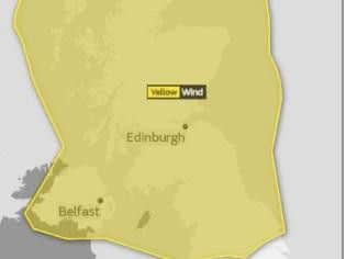
A yellow weather warning for wind from the service says it will hit NI between 3am and 3pm on Thursday.
"Storm Hector will bring a spell of very windy weather on Thursday with gusts of 50 to 60 mph likely," says the Met Office website.
Regarding what the public should expect forecasters say:


Advertisement
Hide AdAdvertisement
Hide Ad"There is a small chance of longer journey times or cancellations as road, rail, air and ferry services are affected
There is a slight chance of some damage to buildings, such as tiles blown from roofs
There is a slight chance that power cuts may occur, with the potential to affect other services, such as mobile phone coverage
There is a small chance that injuries and danger to life could occur from large waves and beach material being thrown onto sea fronts, coastal roads and properties
Advertisement
Hide AdAdvertisement
Hide AdThere is a small chance of injuries and danger to life from flying debris
Disruption to outdoor activities is also likely, with damage to tents, marquees and other temporary structures."
Met Office forecaster Nicola Maxie said: “Storm Hector was named this morning by Met Eireann and the Met Office. It happened around 6.30am.”
She said the decision was made to name the storm as “the strong winds at this time of the year, of winds of 50-60mph with an isolated chance of seeing 70mph in places, is not usual for this time of the year”.
Advertisement
Hide AdAdvertisement
Hide AdShe added that it was important to alert families with “garden furniture out and toys in the garden”.
“It is important to warn the public about the impact strong winds coming through. might have,” she added.