Storm Kathleen: flights back to normal but major tourist attraction forced to close
and live on Freeview channel 276
Although the Met Office weather warning was no longer in place on Sunday morning, conditions remained blustery on Sunday as the clean up operation began.
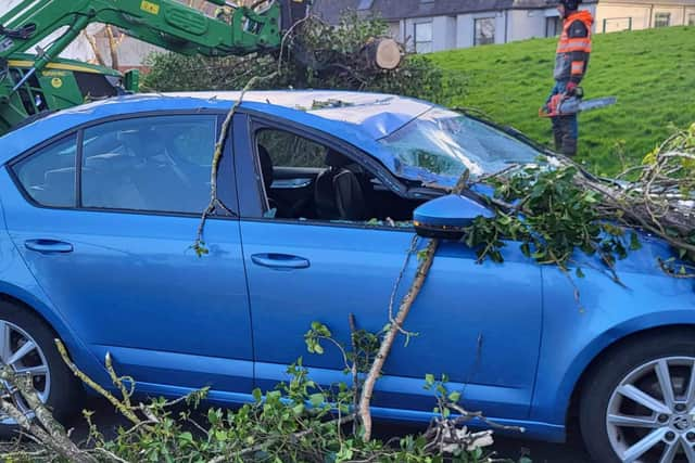
Several roads were blocked by fallen trees, and there was flooding on some roads at the height of the storm on Saturday.
Advertisement
Hide AdAdvertisement
Hide AdThe Titanic Belfast visitor attraction was closed due to damage to its roof and many parks were closed to the public due to the risk of falling trees, including Crawforsdsburn Country Park and the Stormont Estate.
In a social media message on Sunday morning Titanic Belfast urged the public to stay away from the site, saying the attraction would have to remain closed until Tuesday.
It said: "Due to further damage to the roof caused yesterday by Storm Kathleen, @TitanicBelfast has taken the precautionary measure to close its building to the public until Tuesday 9 April. Please see www.titanicbelfast.com/closure for further information."
The message also said that access to the roof to assess the damage is being prevented by the “ongoing inclement weather,” and that anyone with prebooked tickets for the attraction will be notified and refunded.
Advertisement
Hide AdAdvertisement
Hide AdTitanic Belfast goes on to say that as safety is the main priority, access to the plaza surrounding the iconic building has also been prohibited and the public is being asked to stay away from the site.

Stena Line and P&O cancelled a number of Cairnryan sailings in and out of their ports in Belfast and Larne, with 7.30pm Stena Line sailings leaving both Cairnryan and Belfast on Saturday delayed.
Stena Line services between Dublin and Holyhead were cancelled.
Thousands of air passengers across the UK were hit by delays after about 140 flights were cancelled due to the windy conditions, including Aer Lingus flights to and from Belfast City Airport.
Advertisement
Hide AdAdvertisement
Hide AdHowever, parts of the UK saw the hottest temperatures of the year so far on Saturday with a reading of 20.9C in Santon Downham, Suffolk.

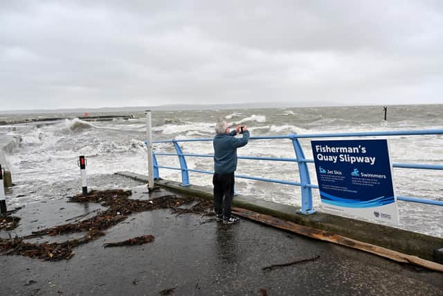
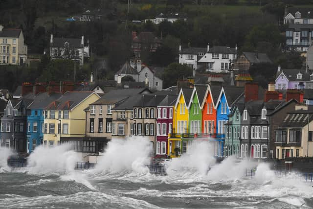
The Met Office had warned of blustery showers in parts of Northern Ireland, with strong to gale force southerly winds and possibly severe gales for a time along the Down and Antrim coasts.
In a message at lunchtime on Sunday, the PSNI said: “The effects of (Saturday’s) storm are still being felt throughout the province, as flooding and fallen trees continue to cause travel disruption.
"Please exercise caution on the roads, and leave additional time for your journey where necessary.”
Advertisement
Hide AdAdvertisement
Hide AdThe forecast for Sunday is for continuing strong winds with sunny spells and a few scattered showers, becoming more frequent in the afternoon.
Fresh to strong southwesterly winds are exepcted to ease later in the day, with a maximum temperature of 14C.
Commenting on the outlook for Sunday evening and into the new week, the Met Office said: “Some late sunshine this evening with showers dying out. Then the rest of the night will be dry with clear periods. A chilly night to come. Minimum temperature 4C… after a dry morning [on Monday], thickening cloud will bring rain across the south and east, but the northwest should remain mostly dry. Maximum temperature 10C.”
Outlook for Tuesday to Thursday is for more unsettled weather with a mixture of sunny spells and scattered showers.
Advertisement
Hide AdAdvertisement
Hide AdStorm Kathleen, named by the Irish meteorological service Met Eireann, is the 11th named storm in eight months.
The Met Office's shipping forecast had 30 gale warnings in place on Saturday afternoon for sea areas including Viking, Plymouth, Biscay, Sole and Lundy.
The Environment Agency issued 15 flood warnings - where flooding is "expected" - and 115 flood alerts in England on Saturday, with National Resources Wales issuing six flood alerts.
The Environment Agency also issued 45 red cautions for strong streams on the River Thames, advising users of all boats not to navigate.
Advertisement
Hide AdAdvertisement
Hide AdRAC Breakdown spokesman Rod Dennis said: "This intense period of stormy weather is going to prove extremely challenging for anyone driving on the western side of the UK.
"We strongly urge drivers to avoid exposed coasts and higher routes where the impact of the very strong winds is most likely to be felt."
Comment Guidelines
National World encourages reader discussion on our stories. User feedback, insights and back-and-forth exchanges add a rich layer of context to reporting. Please review our Community Guidelines before commenting.