Council leverages digital mapping to keep community informed and support local business


Built using Esri’s mapping software ArcGIS, the council created an interactive Open for Business map, which shows what shops and services are available to the public throughout the borough.
The map also shows business opening hours, delivery and collection information and what safety measures the business has in place, all helping to support local enterprises as they reopen.
Advertisement
Hide AdAdvertisement
Hide AdA dedicated COVID-19 information and advice hub also built using ArcGIS is available on the Causeway Coast and Glens Borough Council website and homes a wide collection of resources with further information and advice for local businesses, vulnerable members of society and the wider community in the area.
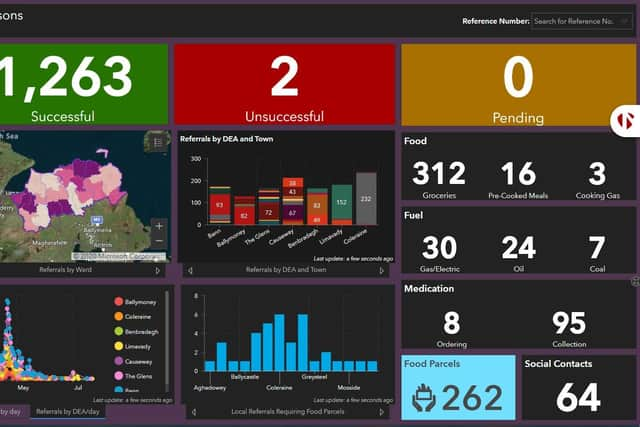
The council’s COVID-19 Coordination Hub connects people to vital community support services and has had more than 1,200 referrals to date from Advice NI and the Northern and Western Health and Social Care Trusts. It helps provide an important continuation of services and access to supports for the most vulnerable people during the pandemic.
Formed in 2015 following the merger of four different councils, Causeway Coast and Glens Borough Council provides public services to more 144,000 citizens throughout the region. Since its formation, the council has worked closely with Esri Ireland to implement GIS across the entire organisation, digitally transforming its services to enhance engagement with the public and enable better, more informed decision making.
Esri’s software enables legal and finance teams to view all of the council’s agreements, leases and licences on one secure platform, eliminating the need to review unwieldy paper-based records and saving both time and money for the council.
Advertisement
Hide AdAdvertisement
Hide AdEsri’s survey app, Survey123, enables field-workers to gather data on mobiles, tablets and laptops from anywhere in the borough. This information, for example on the condition of local facilities and amenities, can be made available to view across the entire council for analysis in real-time.
Philip McLaughlin, Client Manager, Esri Ireland, said: “COVID-19 has highlighted the importance of clear communication between local government and the public. Having already rolled out GIS across many functions, Causeway Coast and Glens Borough Council was well-placed to leverage the power of digital mapping to create numerous rich information resources that are proving incredibly helpful to local businesses and residents.
“In both supporting people and businesses during COVID-19, as well as using GIS to transform its processes and services, Causeway Coast and Glens Borough Council has shown what is possible for a local authority willing to transform how they engage and collaborate with their community.”
Nial McSorley, Digital Services Manager, Causeway Coast and Glens Borough Council, said: “The biggest challenge for us as a council is in how to interpret the sheer volume of information that is available today. With Esri’s digital platform, we can compress all the different information channels into a single source, enabling us to meaningfully analyse and use data to make intelligent decisions.
Advertisement
Hide AdAdvertisement
Hide Ad“As we look to move on responsibly from COVID-19 restrictions, we will again leverage digital mapping to stimulate local tourism and support the reopening of businesses. Beyond that, we will continue to roll out GIS to further areas in the council and ensure all members of our staff can access and use the platform to enhance every aspect of the public services we deliver.”
A message from the Editor:
Thank you for reading this story on our website. While I have your attention, I also have an important request to make of you.
In order for us to continue to provide high quality and trusted local news on this free-to-read site, I am asking you to also please purchase a copy of our newspaper whenever you are able to do so.
Our journalists are highly trained and our content is independently regulated by IPSO to some of the most rigorous standards in the world. But being your eyes and ears comes at a price. So we need your support more than ever to buy our newspapers during this crisis.
Advertisement
Hide AdAdvertisement
Hide AdWith the coronavirus lockdown having a major impact on many of our local valued advertisers - and consequently the advertising that we receive - we are more reliant than ever on you helping us to provide you with news and information by buying a copy of our newspaper when you can safely.
You can also enjoy unlimited access to the best news from across Northern Ireland and the UK by subscribing to newsletter.co.uk
With a digital subscription, you can read more than five articles, see fewer ads, enjoy faster load times, and get access to exclusive newsletters and content. Visit https://www.newsletter.co.uk/subscriptions now to sign up.
Thank you