Titanic’s new ‘digital twin’ shows wreck in highest ever level of detail
and live on Freeview channel 276
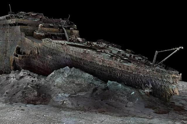
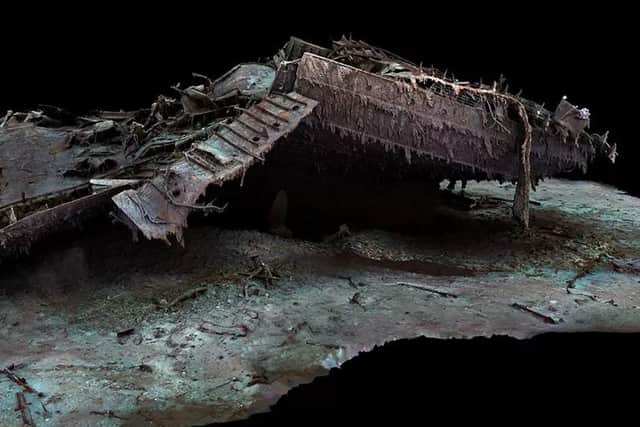
Using technology developed and perfected over five years by deep water specialist Magellan Ltd the exact condition of wreck has been revealed and the entire historic site has been mapped providing a level of detail never before seen – so detailed that even the serial number on the blade of one of the ship's propellers can be made out in the 3D images.
The Belfast-built Titanic, which sank into the Atlantic in 1912 after hitting an iceberg while on its maiden voyage from Southampton to New York, lies in two parts 3,800m beneath the surface of the Atlantic Ocean.
Advertisement
Hide AdAdvertisement
Hide AdDeepwater specialists Magellan, who are based in Guernsey, mapped the ship and its three-mile debris field using more than 715,000 images and full 4k video footage of the wreck, which were taken using two submersibles – named Romeo and Juliet.

Parks Stephenson, a Titanic expert who has studied the ship for the last 20 years, described the project as a "true game-changer".
"What we are seeing for the first time is an accurate and true depiction of the entire wreck and debris site," he said.
"I'm seeing details that none of us have ever seen before and this allows me to build upon everything that we have learned to date and see the wreck in a new light.
Advertisement
Hide AdAdvertisement
Hide Ad"We've got actual data that engineers can take to examine the true mechanics behind the breakup and the sinking and thereby get even closer to the true story of the Titanic disaster.
"For the next generation of Titanic exploration, research and analysis, this is the beginning of a new chapter."
Previous optical images of the ship were limited by low light level and the poor light quality around the ship, the new mapping technique has “effectively taken away the water and let in the light,” the press release said.
Richard Parkinson, founder of Magellan, said: "Over the course of the Titanic project the volume of data that we acquired was enormous – around 7150,000 images and some 16 terabytes of data.
Advertisement
Hide AdAdvertisement
Hide Ad"We believe that this data is approximately ten times larger than any underwater 3D model that's ever been attempted before."
Magellan's 3D capture specialist Gerhard Seiffert, who led the planning for the expedition, said the company's digital twin provides a "highly accurate photorealistic 3D model" of the wreck.
"This model will allow people to zoom out and to look at the entire thing for the first time," he said.
"So, by capturing this 3D model, what we're able to do is visualize the wreck in a completely new way, there's all kinds of amazing small little details that you can see.
"This is the Titanic as no one had ever seen it before."
The scan was carried out in summer 2022 by Magellan Ltd and Atlantic Productions, who are making a documentary about the project.