After double yellow weather warnings Storm Betty brings half a months rain to Northern Ireland overnight as winds batter coastal areas with localised flooding
and live on Freeview channel 276
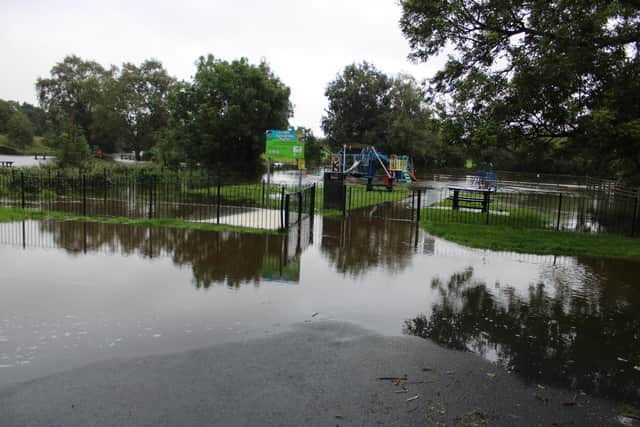
It has been reported that Northern Ireland received half of the normal August rainfall overnight. Northern Ireland had been under a double yellow weather warning for wind and rain.
The rain warning was due to expire at 6am while the warning for high wind in coastal areas expires at 12noon.
Advertisement
Hide AdAdvertisement
Hide AdThe M1 Motorway was closed at Junction 8 Blaris due to a fallen tree obstructing all lanes. Motorists were asked to leave the Motorway at either Junction 7 Sprucefield or Junction 8 Blaris.

Police had also advised of disruption on roads across Belfast due to the weather conditions.
A number of roads were flooded or impassable, including the Upper Knockbreda Road, Castlereagh Road and Loughview Road areas.
They also asked that road users exercise caution in all areas of the country as high winds and rain made driving conditions difficult.
There was also flooding reported in Katesbridge, Co Down.
Advertisement
Hide AdAdvertisement
Hide Ad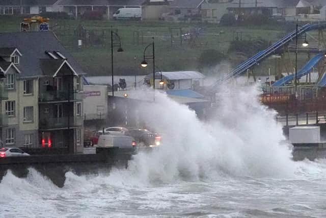
The Met Office had advised ‘Very strong and gusty winds, associated with Storm Betty, will bring some disruption to transport, travel and temporary infrastructure’
Some damage to buildings, such as tiles blown from roofs, could happen
Road, rail, air and ferry services may be affected, with longer journey times and cancellations possible Some roads and bridges may close
The storm caused flooding on some roads in the south of Ireland as the Irish Government’s national weather emergency team warned of the potential for further floods amid strong winds and rain across the country.
Advertisement
Hide AdAdvertisement
Hide AdThere was traffic disruption on some roads across Co Cork and frantic scenes in Co Waterford as a boat broke free from its berth and crashed into a harbour in Dungarvan.
Betty is the second storm named in August, following Storm Antoni which occurred earlier this month.
This is the second time since storm naming was introduced in 2015 that two storms have been named in August, following Ellen and Francis in August 2020.
Met Office chief meteorologist Jason Kelly said the storm had been expected to have the most impact in Ireland and many reported a restless night as homes were battered by wind and rain.
Advertisement
Hide AdAdvertisement
Hide AdThe current Met Office forecast shows an improving situation.
Today:
A cloudy morning with spells of rain. Drier and much brighter weather will extend north in the afternoon. Wind with strong west to southwesterly winds, easing later. Warm in southeast. Maximum temperature 20 °C.
Tonight:
A few sunny spells for the evening but still windy. One or two blustery showers overnight but clear spells expected. Remaining mild. Minimum temperature 14 °C.
Sunday:
Still quite breezy on Sunday with a few blustery showers around, these will pass through quite quickly. Warm in the east. Maximum temperature 22 °C.
Outlook for Monday to Wednesday:
A wet and windy start to the new week, drier in the south. A little brighter on Tuesday and Wednesday but still a few blustery showers.