Met Office says Northern Ireland may see its temperature record smashed in the coming days as parts of the UK set to smoulder in 40C heat


It is predicted that tempuratures in southern England will reach 40C (104F) by early this coming week.
To put that into perspective, the average July tempurature in Riyadh – the desert-bound capital of Saudi Arabia – is 37C (according to Timeanddate.com).
Advertisement
Hide AdAdvertisement
Hide AdOr to put it another way, the highest tempuerature of the past week in Death Valley’s Furnace Creek – the hottest place on Earth – was 49C (same source).
However, the Met Office suggests temperatures could hit about 29C in Belfast on Monday – scorching hot by Ulster standards, but avoiding the extremes expected across the Irish Sea.
And on Tuesday it says the Province could break its all-time temperature record – believed to be 31.4C, recorded by the Met Office in Armagh on July 22 last year at 3.20pm.
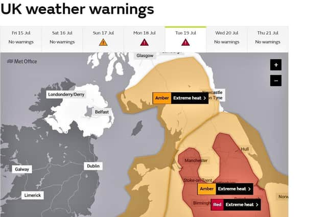
At the same time, the Province is on course to avoid any Met Office weather warnings.
Advertisement
Hide AdAdvertisement
Hide AdAn amber alert for high temperatures during Monday and Tuesday stretches as far north as Stranraer, but just stops short of the Ulster coast.
Over the same time period a red warning covers inland England from Manchester to London.
The Met Office says: “For the first time temperatures of 40°C have been forecast in the UK and the Met Office has issued the first ever red warning for exceptional heat.
“A recent Met Office study found that summers which see days above 40°C somewhere in the UK have a return time of 100-300 years at present, even with current pledges on emissions reductions this can decrease to 15 years by 2100.
Advertisement
Hide AdAdvertisement
Hide Ad“Extreme heat events do occur within natural climate variation due to changes in global weather patterns.
“However, the increase in the frequency, duration, and intensity of these events over recent decades is clearly linked to the observed warming of the planet and can be attributed to human activity.”
As for what all this means for the Province during the coming week, its forecasters believe Saturday will yield a maximum temperature of 22 C.
But from Sunday to Tuesday, the forecast is: “Mostly dry and increasingly sunny, with the afternoon highest lifting day by day – particularly across southern and eastern areas, with some chance of breaking the all time temperature record on Tuesday.”
Advertisement
Hide AdAdvertisement
Hide AdAfter that, much of the UK should see temperatures steadily decrease back down through the middle part of the week, with the risk of heavy rain and thunderstorms.