
Northern Ireland weather: 'Temperatures will become warm again later this week getting back to 21C by Friday and through the weekend' - Met Office
There is ‘a messy picture across the country today – a wet day for some but some warm sunshine in other areas’, according to Alex Deakin from the Met Office.
The top forecaster that ‘after a damp start Northern Ireland should get a lot brighter later’.
He said in NI there will be a ‘warm and humid feel again on Wednesday, but tomorrow looks dry with sunshine lifting the temperatures’.
Meanwhile according to UK weather extreme by the Met Office, the highest maximum temperature yesterday was in Killowen and was 19.9 °C.
The highest rainfall was recorded in Ballypatrick Forest at 4.2 mm.
And the sunniest area of Northern Ireland was reported as being Katesbridge at 2.1 hours.
And Met Office forecaster Oli Claydon said: “In terms of temperatures, there is nothing in our forecast showing another heatwave for Northern Ireland, though temperatures will become warm again later this week getting back to 21C by Friday and through the weekend.
"The forecast is quite changeable for Northern Ireland this week, there will be some sunny spells though there will be showers moving through at times as well as some more heavy showers on Thursday”.
Meanwhile according to the report from the Met Office Northern Ireland this afternoon ‘will be dry and rather cloudy, the occasional brighter spell possible across eastern counties’ and there will be a maximum temperature 19 °C.
Tonight ‘will be dry and mostly cloudy’ but there is the ‘chance of the odd shower in the west’.
There will be a minimum temperature 12 °C.
And tomorrow (Wednesday) we will see ‘some early brightness’ but ‘otherwise a dry and cloudy day’.

‘Rain will spread northeast during the evening’ and it will be ‘quite warm’ with a maximum temperature 20 °C.
The outlook for Thursday to Saturday is: ‘Overnight rain clearing away on Thursday morning then dry and bright. Cloudy with occasional rain on Friday. Dry and bright on Saturday’.
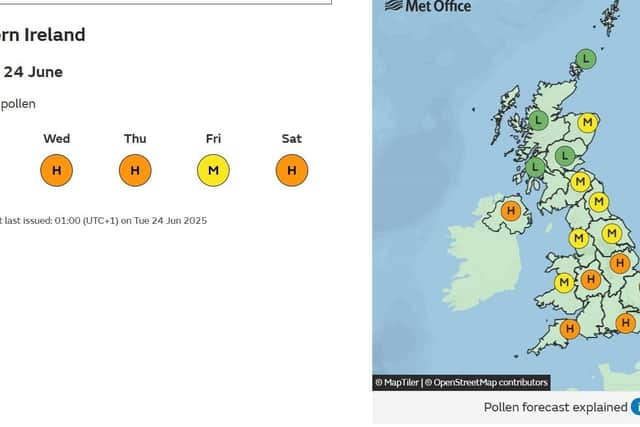
The outlook is also not great for hay fever sufferers with a forecast of HIGH for today, Wednesday, Thursday and Saturday.
It forecasts a MEDIUM pollen count for Friday.
See the Met Office pollen forecast here
Looking further ahead – Saturday 28 Jun - Monday 7 Jul – ‘Weather conditions are expected to be remain changeable through this period, as a series of Atlantic low pressure systems pass to the northwest of the UK.
‘These will tend to bring some occasional rain or showers, most frequent in northwestern areas where it may also be rather breezy or windy at times.
‘Whilst some rain or showers will be possible across the south and east, here longer drier spells are more likely, under the influence of higher pressure.
‘There is also the chance of some occasional very warm, perhaps locally hot weather, as south or southwesterly winds allow brief bursts of hotter air to encroach from the continent, but probably fairly short-lived and perhaps also accompanied by a few thunderstorms at times’.
Meanwhile the forecast for Tuesday 8 Jul - Tuesday 22 Jul is: ‘A continuation of changeable conditions is most likely for the first part of July.
‘The wettest and windiest conditions most likely towards the northwest with a risk of some heavy rain at times, especially over hills.
‘Southern and eastern areas are most favoured for longer drier and more settled spells, although even here some occasional rain or showers will be possible, perhaps thundery.
‘There are signs of more widely settled weather during the second half of July, however this signal is very tentative.
‘Temperatures are expected to be above average for most areas, especially towards the southeast where there will be an ongoing chance of some very warm or hot conditions at times’.