
Storm Eowyn: Rush hour risk as winds of up to 90mph set to batter Northern Ireland during Friday morning commute - Met Office warns roads could be shut and trains, flights and ferries stopped
Rush hour commuters have been warned to avoid travelling on Friday morning, as gusts of up to 90mph hit Northern Ireland.
The Met Office has advised people across province to work from home as much as possible, telling the News Letter that commutes will be dangerous as a result of gale-force winds from Storm Eowyn.
Winds that strong will be felt by drivers who could struggle to keep control, a spokeswoman said, while people are advised not to try cycling as the risk to their safety is too great.
Roads and bridges may be shut, while commuters could be in danger from flying debris or waves crashing over coastal areas.

Pedestrians will feel the impact too, while trains may be cancelled, ferries stopped and flights grounded.
The spokeswoman said people should avoid travelling as much as possible during Friday morning, and advised any motorists who do hit the road to go much slower than usual.
An amber weather covering the whole of Northern Ireland is in place from 6am to 9pm on Friday, but the strongest gusts are due to strike Northern Ireland around 9am – meaning they’ll hit rush hour traffic.
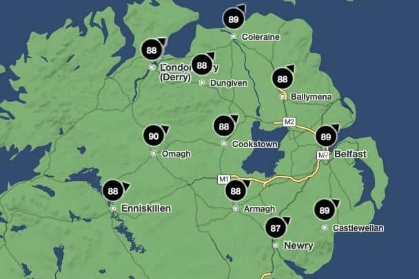
According to the Met Office, winds of up 90mph could hit Omagh, while Belfast, Coleraine and Castlewellan could all see gusts maxing out at 89mph.
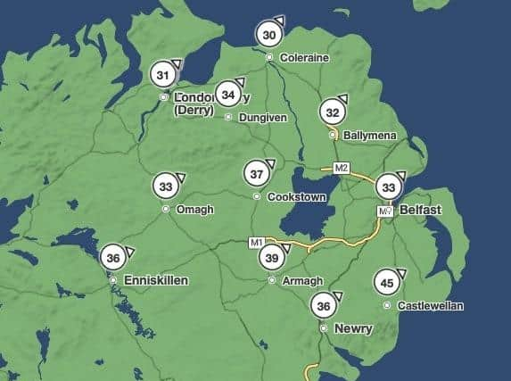
Although the average wind speed across much of the province around that time of day will be between 31mph and 34mph, forecasters say Armagh could see average speeds of 39mph while Castlewellan averages as high as 45mph.
The wind will slowly ease off over the course of the day, by the evening reaching maximum and average speeds around half those seen during morning rush hour.
But that’s still much more intense than normal, and forecasters have warned of traffic disruption and travel difficulties throughout the course of the day.
The Met Office stated there’s also a chance of damage to buildings, including roofs being blown off, and power lines being torn down by the storm.
Said the spokeswoman: "Injuries and danger to life could occur from flying debris, as well as large waves and beach material being thrown onto seafronts, coastal roads and properties."
Saturday is expected to be relatively calm, but more unsettled weather is due to hit on Sunday.
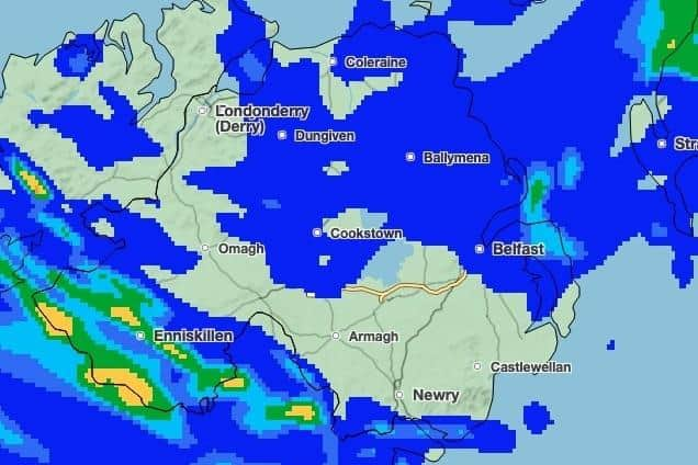
A band of heavy rain is set to move in from the south-east over Sunday afternoon, sweeping up and across the entire province over the course of the day.
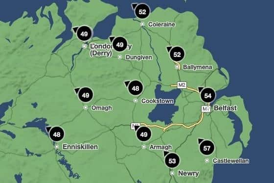
Strong winds are also expected, with maximum gusts of 57mph in Castlewellan, 54mph in Belfast and 52mph in the north-east.
The western half of Northern Ireland won’t be as badly affected by wind that day, seeing maximum gusts of around 48mph to 49mph.
Moving into next week, Monday and Tuesday are expected to be more windy than average for this part of the world – but not even the extent seen on Sunday, let alone Friday’s extremes.