Flights and ferries cancelled and forest parks closed as Storm Kathleen hits Northern Ireland
and live on Freeview channel 276
About 70 flights departing and arriving at UK airports before midday on Saturday have already been cancelled including all Aer Lingus services cancelled at Belfast City Airport, as the Met Office issued a yellow weather warning for wind.
Belfast City Airport website showed many cancelled flights, but at Belfast International Airport’s site Easyjet and some other airlines were showing as going ahead.
Advertisement
Hide AdAdvertisement
Hide AdStena Line’s two ferry services from Belfast to Liverpool and vice versa appeared to be operating as normal but the 1130am and 330pm sailings to and from Cairnryan were cancelled with the 730pm listed as delayed.
Roads were disrupted in places. The Comber Road, Killyleagh was closed to motorists as of late morning following a report of a fallen tree which has brought down an electrical cable. Police said: “Please seek an alternative route for your journey.”
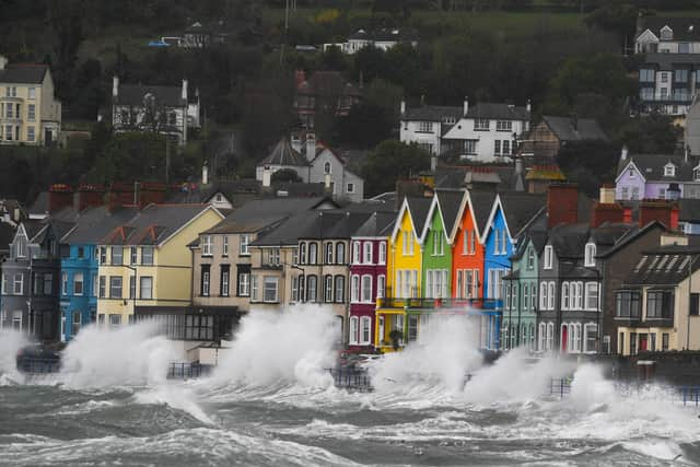
The Portaferry Road outside Newtownards was impassable as of lunchtime due to flooding. The PSNI said: “Please avoid the area, particularly with today's high winds, and find another route for your journey.”Storm Kathleen swept across the island of Ireland from the early hours of Saturday, although the Irish Sea had significant waves on Friday. In Northern Ireland, the Met Office issued a yellow wind warning for counties Antrim, Armagh, Down, Fermanagh, Tyrone and Londonderry, which will stay in place from 8am until 10pm.
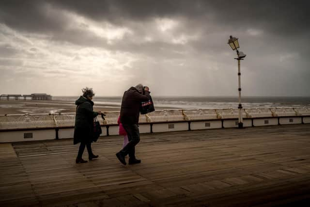
It has warned of blustery showers in parts of the region, with strong to gale force southerly winds and possibly severe gales for a time along the Down and Antrim coasts. Some exposed and coastal areas could see gusts reaching higher speeds of up to 70mph.
Advertisement
Hide AdAdvertisement
Hide AdMulti-agency partners including the PSNI, NIE, the Department for Infrastructure and other emergency response and public sector organisations have met to prepare for Storm Kathleen.

Stormont’s Department of Infrastructure said that “staff from all agencies are monitoring the situation and making preparations to respond to any impacts”. They warned of debris on the roads, fallen trees and spray or large waves on exposed and vulnerable coastal areas.
“Traffic disruption is possible so please plan ahead, stay up to date with the latest weather and travel advice and take extra care if travelling.” Advice and information on the current weather warnings is available at: Strong winds warning - www.nidirect.gov.uk/news/strong-winds-weather-warning-information-and-advice
The statement said: "Due to the current weather warning issued by the Met Office for high winds, DAERA is advising the public not to visit Forests, Country Parks and Nature Reserves while the weather warning is in place. Vehicular access to forests, including for caravanning and camping, is suspended for the duration of the weather warning.”
Advertisement
Hide AdAdvertisement
Hide AdThe department said it may be necessary to close some roads or put temporary restrictions in place. Road users are reminded to adhere to road signs and any temporary traffic lights. “If you need to travel reduce your speed, stay well behind the vehicle in front, remain focused and always wear your seatbelt. Traffic information can be found at Trafficwatchni - TrafficWatchNI - Home. You can report an obstruction at: Report an obstruction on a road or street | nidirect .”
Monitoring of river levels and tidal surges has been ongoing and will continue until the weather warnings have elapsed.
"Rivers teams remain on standby and have been checking and clearing drainage screens and other assets. Regional Community Resilience Groups have also been advised of weather patterns and to make appropriate preparations.
“The power of water is often on show during a storm as waves crash against harbour walls, piers and cliffs. It looks spectacular but surges can easily sweep a person off their feet and into trouble. All it takes is one wave to drag you out to sea – a dramatic photograph or selfie is not worth risking your life. If you see someone get carried away by a wave, call 999 and ask for Coastguard.”
Advertisement
Hide AdAdvertisement
Hide AdThe statement said that NIE Networks are on standby should there be any damage caused to the electricity network and are keen to remind the public to maintain safety around any damaged electricity equipment. Members of the public should never approach a broken pole or electricity line and instead report it immediately to the customer helpline on 03457 643 643.
“Should customers experience a power cut they can report the fault online at www.nienetworks.co.uk or call the NIE Networks Customer Helpline on 03457 643 643. Customers can also follow NIE Networks on social media for regular updates.
“Members of the public should continue to report incidents of flooding to the flooding incident line on 0300 2000 100. Calls taken by the incident line staff are passed to the relevant responding Agency.”
In the Republic, an orange wind warning kicks in for Cork, Kerry and Waterford from 7am until 2pm, while another status orange wind warning is in place for Galway and Mayo from 9am until 6pm. A yellow wind warning is in place nationwide from the early hours of Saturday until 8pm.
Advertisement
Hide AdAdvertisement
Hide AdForecaster Met Eireann warned that there will be gale force southerly winds that will bring a risk of difficult travel conditions, fallen trees, some power outages and flooding along coastal areas.
Met Office meteorologist Ellie Glaisyer told the PA news agency: "The storm is the reason we are seeing the warmer temperatures, because the location of the storm - situated out towards the west of the UK - is bringing a southerly wind across the UK.
"This is bringing those warmer temperatures from the continent, meaning we are likely to see temperatures reaching 22C."
The highest temperature of the year so far was 19.9C, recorded at the end of January at Achfary in north-west Scotland.
Advertisement
Hide AdAdvertisement
Hide AdStorm Kathleen is also expected to bring 50-60mph winds quite widely on Saturday, while some Irish Sea coastal regions will see gusts up to 70mph and large waves.
Ms Glaisyer said: "Almost anywhere is going to see above-average temperatures. Western parts of the UK are likely to see temperatures of 15 or 16C.
"However, the further west you are, where those strongest winds are in that yellow warning area, despite the temperatures being above average it will feel a little colder."
On Friday, the Met Office updated its weather warning to forecast stronger gusts during Storm Kathleen than previously predicted.
Advertisement
Hide AdAdvertisement
Hide AdIt warned of injuries and danger to life from "large waves and beach material being thrown on to sea fronts, coastal roads and properties", a possibility that "road, rail, air and ferry services may be affected" and the potential for power cuts and phone service outages.
The forecaster said winds would stay strong into Sunday, particularly in northern parts of Scotland.
"There will still be some showers around, but there should be some sunshine between those showers", Ms Glaisyer said, adding: "It is generally remaining unsettled through much of next week.
"There is another area of low pressure moving towards the UK through Monday and into Tuesday. That is likely to bring some heavy rain for much of the UK, particularly in the West."
Advertisement
Hide AdAdvertisement
Hide AdStorm Kathleen, named by the Irish meteorological service Met Eireann, is the 11th named storm in eight months.
It is only the second time in a UK storm season that the letter K has been reached in the alphabet.
The Met Office's shipping forecast had 29 gale warnings in place on Saturday morning for sea areas including Viking, Plymouth, Biscay, Sole and Lundy.
The Environment Agency issued 14 flood warnings - where flooding is "expected" - and 113 flood alerts in England on Saturday, with National Resources Wales issuing six flood alerts.
Advertisement
Hide AdAdvertisement
Hide AdThe Environment Agency also issued 45 red cautions for strong streams on the River Thames, advising users of all boats not to navigate.
RAC Breakdown spokesman Rod Dennis said: "This intense period of stormy weather is going to prove extremely challenging for anyone driving on the western side of the UK.
"We strongly urge drivers to avoid exposed coasts and higher routes where the impact of the very strong winds is most likely to be felt