Storm Kathleen batters Northern Ireland, bringing down trees and leading to cancelled flights and ferries and closed forest parks
and live on Freeview channel 276
The Titanic Belfast visitor attraction was closed after damage was caused to part of the roof of the building. Harbour Police have closed the road outside the structure. Vehicles were not allowed into forest and other parks such as Crawfordsburn Country Park in Co Down, one of the most visited locations in all of Northern Ireland.
Stena Line and P&O cancelled a number of Cairnryan sailings in and out of their ports in Belfast and Larne, with 7.30pm Stena Line sailings leaving both Cairnryan and Belfast delayed. Stena Line services between Dublin and Holyhead were cancelled.
Advertisement
Hide AdAdvertisement
Hide AdThousands of air passengers across the UK were hit by delays after about 140 flights were cancelled due to the windy conditions, including Aer Lingus flights to and from Belfast City Airport.
Motorists were advised that a tree fell on the Saintfield Road, Carryduff, and was blocking both lanes just past the roundabout. “Traffic is able to pass very slowly using the layby, but knock-on delays are to be expected,” police said. “Please seek an alternative route for your journey where possible.”
The Drones Road, Dunloy, was impassable from the junction with Kilmandil Road, due to a fallen tree and power lines, as was the Comber Road, Killyleagh with a fallen tree which brought down an electrical cable. The Portaferry Road outside Newtownards was impassable due to flooding, with motorists advised to avoid the area.
But parts of the UK saw the hottest temperatures of the year so far, with a reading of 20.9C in Santon Downham, Suffolk, and even in Northern Ireland the temperatures were mild and it was sunny for much of the day in places. Strong winds also swept in, with 73mph recorded in Drumalbin, Lanarkshire in Scotland, the forecaster said.
Advertisement
Hide AdAdvertisement
Hide AdThe Met Office issued a yellow weather warning for wind, that will be in place until 10pm counties Antrim, Armagh, Down, Fermanagh, Tyrone and Londonderry, western England and Scotland.

The Met Office has warned of blustery showers in parts of Northern Ireland, with strong to gale force southerly winds and possibly severe gales for a time along the Down and Antrim coasts. Some exposed and coastal areas could see gusts reaching higher speeds of up to 70mph.
A further yellow warning for wind has been issued for north-west Scotland on Sunday between 9am and 3pm, with gusts of up to 70mph expected again, according to the Met Office.
Major travel disruption saw flights cancelled at airports including Heathrow, Manchester, Birmingham, Edinburgh and Belfast City. The majority of flights affected were those within the UK and to and from Ireland.
Advertisement
Hide AdAdvertisement
Hide AdMulti-agency partners including the PSNI, NIE, the Department for Infrastructure and other emergency response and public sector organisations have met to prepare for Storm Kathleen.
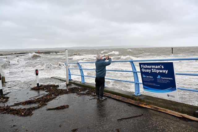
Stormont’s Department of Infrastructure said that “staff from all agencies are monitoring the situation and making preparations to respond to any impacts”. They warned of debris on the roads, fallen trees and spray or large waves on exposed and vulnerable coastal areas.
“Traffic disruption is possible so please plan ahead, stay up to date with the latest weather and travel advice and take extra care if travelling.” Advice and information on the current weather warnings is available at: Strong winds warning - www.nidirect.gov.uk/news/strong-winds-weather-warning-information-and-advice
The statement said: "Due to the current weather warning issued by the Met Office for high winds, DAERA is advising the public not to visit Forests, Country Parks and Nature Reserves while the weather warning is in place. Vehicular access to forests, including for caravanning and camping, is suspended for the duration of the weather warning.”
Advertisement
Hide AdAdvertisement
Hide AdThe department said it may be necessary to close some roads or put temporary restrictions in place. Road users are reminded to adhere to road signs and any temporary traffic lights. “If you need to travel reduce your speed, stay well behind the vehicle in front, remain focused and always wear your seatbelt. Traffic information can be found at Trafficwatchni - TrafficWatchNI - Home. You can report an obstruction at: Report an obstruction on a road or street | nidirect .”
Monitoring of river levels and tidal surges has been ongoing and will continue until the weather warnings have elapsed.
"Rivers teams remain on standby and have been checking and clearing drainage screens and other assets. Regional Community Resilience Groups have also been advised of weather patterns and to make appropriate preparations.
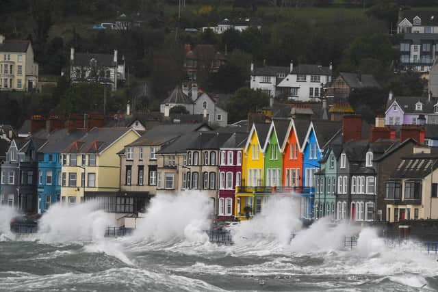
“The power of water is often on show during a storm as waves crash against harbour walls, piers and cliffs. It looks spectacular but surges can easily sweep a person off their feet and into trouble. All it takes is one wave to drag you out to sea – a dramatic photograph or selfie is not worth risking your life. If you see someone get carried away by a wave, call 999 and ask for Coastguard.”
Advertisement
Hide AdAdvertisement
Hide AdThe statement said that NIE Networks are on standby should there be any damage caused to the electricity network and are keen to remind the public to maintain safety around any damaged electricity equipment. Members of the public should never approach a broken pole or electricity line and instead report it immediately to the customer helpline on 03457 643 643.
“Should customers experience a power cut they can report the fault online at www.nienetworks.co.uk or call the NIE Networks Customer Helpline on 03457 643 643. Customers can also follow NIE Networks on social media for regular updates.
“Members of the public should continue to report incidents of flooding to the flooding incident line on 0300 2000 100. Calls taken by the incident line staff are passed to the relevant responding Agency.”
Around 34,000 customers have been left without electricity with power outages in the Republic of Ireland, concentrated in Mayo, Galway, Kerry and Cork.
Advertisement
Hide AdAdvertisement
Hide AdMet Office meteorologist Ellie Glaisyer told the PA news agency: "The storm is the reason we are seeing the warmer temperatures, because the location of the storm - situated out towards the west of the UK - is bringing a southerly wind across the UK."
The previous highest temperature of the year was 19.9C, recorded at the end of January at Achfary in north-west Scotland.
Meanwhile, Saturday evening's EPCR Challenge Cup rugby match between Edinburgh Rugby and Aviron Bayonnais has been moved to Scottish Gas Murrayfield from Hive Stadium because of the strong winds expected.
On Friday, the Met Office updated its weather warning to forecast stronger gusts during Storm Kathleen than previously predicted.
Advertisement
Hide AdAdvertisement
Hide AdIt warned of injuries and danger to life from "large waves and beach material being thrown on to sea fronts, coastal roads and properties", a possibility that "road, rail, air and ferry services may be affected" and the potential for power cuts and phone service outages.
Storm Kathleen will ease on Sunday evening, but another weather system towards the South West will replace it, Ms Glaisyer added.
She said: "Outbreaks of rain through Monday will mainly affect western parts of the UK. As we go through the day into Tuesday we're likely to see the strongest wind across the south-west of the UK.
"It's coming relatively quickly after Storm Kathleen.
"It's not out of the question that a warning could be issued but I wouldn't like to say yet."
Advertisement
Hide AdAdvertisement
Hide AdStorm Kathleen, named by the Irish meteorological service Met Eireann, is the 11th named storm in eight months.
It is only the second time in a UK storm season that the letter K has been reached in the alphabet.
The Met Office's shipping forecast had 30 gale warnings in place on Saturday afternoon for sea areas including Viking, Plymouth, Biscay, Sole and Lundy.
The Environment Agency issued 15 flood warnings - where flooding is "expected" - and 115 flood alerts in England on Saturday, with National Resources Wales issuing six flood alerts.
Advertisement
Hide AdAdvertisement
Hide AdThe Environment Agency also issued 45 red cautions for strong streams on the River Thames, advising users of all boats not to navigate.
RAC Breakdown spokesman Rod Dennis said: "This intense period of stormy weather is going to prove extremely challenging for anyone driving on the western side of the UK.
"We strongly urge drivers to avoid exposed coasts and higher routes where the impact of the very strong winds is most likely to be felt."